In this guide, let me show you how to enable and use street view in Google Maps. Google Maps is your go-to app when finding directions in an unknown place, locating that hyped restaurant, or the tourist attraction in the city you are visiting.
Typically, when you use Google Maps, you get an overall bird’s eye view recon of the whole city. Then you zoom in on your desired location to know the route. If you enable street view, you can get a panoramic vision of the location you are looking to visit, along with the streets in its vicinity.
I have explained how to use street view in Google Maps using my Android device as an example. If you use Google Maps on an iPhone, the steps pretty much remain the same. Street view is also available for the Google Maps iOS app.
What is Street View in Google Maps?
Street View in Google Maps provides a street-level view of maps. You can explore the world around you with virtual 360-degree panoramic imagery. it even allows you to navigate through the streets virtually.
Initially, the street view feature was available to only selected regions in the world. As of now, the street view has been rolled out widely in many countries.
The best part of the feature is Google constantly keeps updating the resources with the latest images of the locations that you navigate using the online map.
1. How to Enable Street View in Google Maps?
Now, let us check out how to enable street view in Google Maps. Make sure that you are using the latest version of Google Maps. Otherwise, You can update the app by visiting the Play Store app. Within it, look for available updates under Manage Apps & Device.
Secondly, you must have the location enabled on your device. On an Android device, pull down the notification center to reveal the quick settings panel. Tap the location icon to enable it
- Launch Google Maps.
- Tap on the Layers icon.
- Under the tab Map Details, tap on Street View.
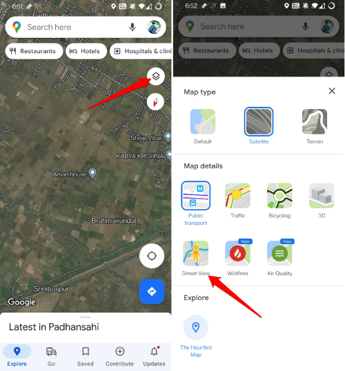
- The street view coverage of the current location/city/region will be marked with blue lines.
That’s all the steps you need to carry out to enable street view in Google Maps on your phone.
2. How to Use Street View in Google Maps?
Learning freshly about Street View in Google Maps and having no idea how to use it? Don’t worry. These steps will guide you. We will continue from the blue lines we saw in the previous section that indicates the street view coverage.
- Launch the street view by tapping the blue line.
- Google Maps will split into a dual screen. You will see the street view of the location on the first half of the screen. The other half will show the map of the corresponding region and a target location marker.
- You can drop the place marker on any point on the map to see the nearest locality in the street view on the split screen.
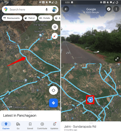
- As you keep changing the place marker from one location to another, the street view will change accordingly.
- The split screen showing the street view will have an expand icon. Tap on it to enter the full-screen view of the Street view generated by Google Maps.
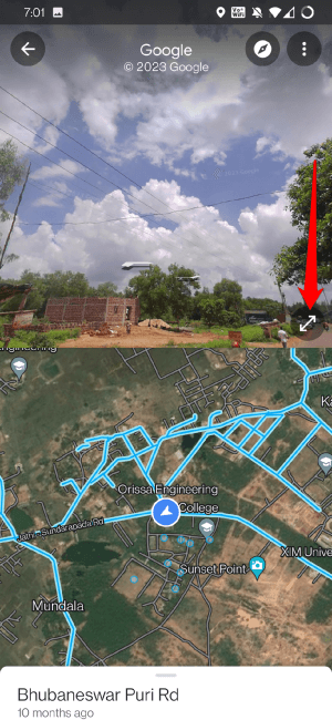
- To zoom into the street view, use your fingers to do a pinch inwards motion on the screen.
- Likewise, to zoom out of the street view, pinch outwards with your fingers on the part of the screen that is displaying the street view.
That’s the simple way to get to use the street view in Google Maps to your advantage. If you are visiting a new place, use this feature to accurately locate your favorite restaurants, shopping centers, taxi stands or hotels pretty easily.
Also Read- How to Save Your Favorite Places in Google Maps
Wrapping Up
Now that you know how to use Street View in Google Maps, you can have a more immersive experience in navigating through new places you visit. Also, locating any landmark with more visual clarity becomes a cakewalk. I hope you found this guide useful.


