Google Maps has always been a savior in our journeys. The web mapping service from Google has all the features to direct us in the right way, using all the data that has been sucked from us. It maintains the list of all the businesses throughout the world listed by anyone and shows us when needed.
This made Maps much resourceful, as one can look up to anything they want in a span of seconds. One example is the gas stations, where Google Maps really come in handy. Google has set up dedicated options to find these outlets quickly, with just a tap of the button. Here’s how;
Also Read- How to Turn Off Google Assistant on Android
Steps to Find Nearest Gas Stations Using Google Maps
- Open your Google Maps app on the phone, and make sure you’re having location (GPS) services turned ON. This helps Google to locate your area, and find relevant outlets nearby.
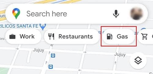
- Now, check for options in the top, where they’re listed as Work, ATMs, Restaurants, Hotels, etc. Among them, you can find Gas as one of the options, tapping on that will show the gas stations near your location.

- This could sometimes be written as Petrol, based on the region. As western countries call it as Gas, which is also the same fuel as Petrol.
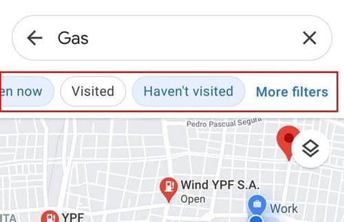
- Spotting the nearest gas station, you can tap on the red balloon to learn more details about the outlet. These include the directions, website (if having), photos, working hours, contact details, and reviews. You’ll also be shown cards of them at the bottom when checking.
- Moreover, you can filter the results as desired. In the above options, you’ll see options like Relevance, Open Now, Visited, Not Visited, and More Filters. Tapping on More Filters will open options for more sorting, like by distance and working hours.

")
")
")