Indian Space Research Organisation recently released a new set of images of the moon’s surface as captured by Chandrayaan – 2. These images are 3D images that showcase the various elements on the moon’s surface.
What are these images?
According to ISRO official twitter handle post, these images are a 3D view of the surface element. These images were captured by the Terrain Mapping Camera-2 (TMC-2), which is being used on the orbiter. TMC – 2 has the capacity of providing at 5m spatial resolution & stereo triplets (fore, nadir, and aft views). These are processed to create DEM images of the complete lunar surface.
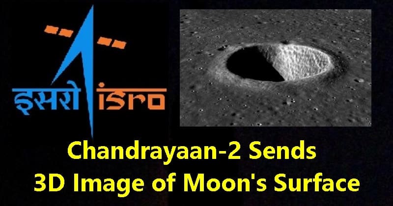
After processing the images into DEM (digital elevation model), you get a 3D CG representation of a terrain surface. You can see the various landform, shapes, and structures of the moon surface.
What are these images useful for?
#ISRO
Have a look of 3D view of a crater imaged by TMC-2 of #Chandrayaan2. TMC-2 provides images at 5m spatial resolution & stereo triplets (fore, nadir and aft views) for preparing DEM of the complete lunar surface.For more details visit https://t.co/urlZqzg3Gw pic.twitter.com/VBvUeH1L8s
— ISRO (@isro) November 13, 2019
These 3D images will be used to study craters, graben structure, lava tubes, collapsed lava tubes, lunar domes, and cones on the moon. Now scientists will have a better understanding of what the moon is made up of.
ISRO planning for Chandrayaan – 3
While the orbiter revolves around the moon, ISRO is planning for Chandrayaan – 3, which is set to launch in November 2020. According to ISRO chairperson, K Sivan, they will also be sending Indian robots along with their spacecraft. These robots will land on the surface and study the surface and explore a different part of the moon.
Other than this, the Vikram lander, which failed in the previous Chandrayaan mission, is also expected to go along and finally land this time. It is suggested that ISRO is talking with scientists from the Chandrayaan-2 project to examine the previous mission. To find any error and rectify them in the current Chandrayaan – 3 mission.
Source – ISRO
")
")
