Google Maps service gets much better with the new update, where the maker has embedded in-depth details of the world’s natural vegetation. Upon zooming out, users can see what an area’s nature looks like. It distinguishes natural resources like rivers, oceans, ravines, or lakes by coloring them as blue, tan, or arid. Further, the street views of specific areas are getting more details too.
Google Maps Puts More Natural Details
Google Maps has grown to be an essential service for the everyday traveler. It has grown from a simple geographical tool to a daily navigational need. Yesterday, the maker Google has announced a new update of this platform, which will be more resourceful as they revamped it with deep natural details.
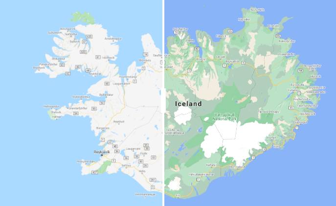
The new update will have more colors based on their underlying vegetation. It is like oceans and seas colored as dark blue, lakes and rivers as light blue, deserts and arid regions as yellow/orange, ice with white, dark forests as dark green and partial shrubs and similar areas with light green.
These details will be more helpful while taking a virtual tour or planning a future trip as embedded with more information. Further, Google also made the street view data of specific areas like San Francisco, London, and New York more detailed. It includes the exact shape and width of streets and the availability of crosswalks, footpaths, pedestrian crossing, etc.
These details are helpful for those looking for sensitive accessibility like a wheelchair or others. Google did this with its satellite imagery, where it analyzed the features and colored them on the HSV color model. This new detailed maps will be coming in the next update, rolling out to everyone starting this week.
Related Articles
- Google Appreciated the Man Who Fooled Their Maps with 99 Smartphones
- Huawei Working on a New Map and Wishes not to Use Google Maps
- Apple Maps Update Extensively in Western, Midwestern United States
- Incognito Mode is On For Google Maps Now, Released For Some Users
- Work From Home Employees May Cause More Cyberthreat to Their Companies
")

